|
The Riviera Maya & Costa Maya |
|
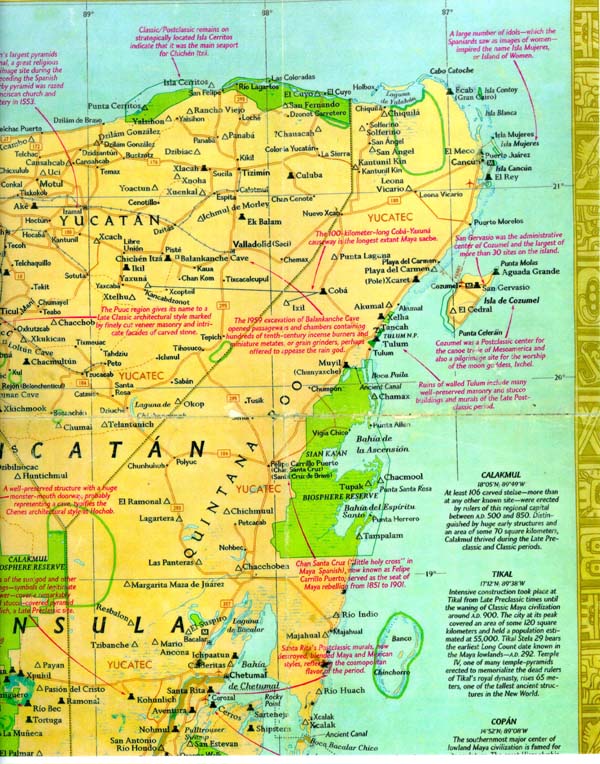
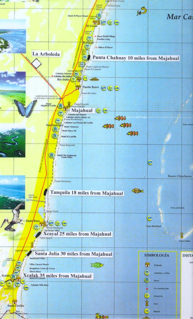
The Riviera Maya and Costa Maya are names that the East coast of the Yucatan Peninsula has recently acquired because of the rapid development of beach resorts. Geographically, the Riviera Maya stretches from Cancun southward to Tulum, along the coast of the Caribbean. Off the coast a few miles away lies the island of Cozumel. These areas are very popular for SCUBA diving and snorkeling, because of the beautiful clear waters of the Caribbean. Also the Mayan ruins and cenotes on the mainland coast are very interesting places for vacationers to visit. Costa Maya is the lower part of the coast from Placer down the coast to the small fishing village of Xcalak. Both parts of the Yucatan Peninsula are in the state of Quintana Roo, or by the abbreviation, Q. Roo. The state capital is Chetumal, but this is an inland city located on Chetumal Bay, just north of the border of Belize. The southernmost Mexican town on the Caribbean coast is Xcalak. We should consider the East coast of the Yucatan in three sections. The northern section, the Riviera Maya, from Cancun to Tulum has been under development for the past thirty years, and has become a widely know resort area. From a small village, Cancun developed into a large coastal city with hundreds of hotels, thousands of rooms, and hundreds of thousands of visitors per year. Just a few years ago, Playa del Carmen was a sleepy little village with a nice beach and the landing pier for the ferry to Cozumel. Now it has developed into a large resort area with luxurious hotels and resort type residential housing developments. A four lane freeway connects Cancun with Both Tulum to the south and Merida to the west. The center third of the Yucatan East coast has been reserved as a "Biosphere." There are two large bays, but development will be almost non existent by design, controlled by severe subdivision and building restrictions. It is good to keep this area of the coast reserved for the ecological benefit of this part of the Caribbean coast. There are two other geographical features of great importance. One is the barrier reef that runs the entire length of the Yucatan East coast from Cancun all the way to Ambergris Cay, Belize. This is the second longest barrier reef in the world, and is invaluable for protecting the beaches in most areas from erosion. It also provides a convenient area for protecting boats at anchor, making harbors unnecessary. The second is Banco Chinchorro, which is a very large reef located 18 miles offshore from Costa Maya. The reef is one of only four atolls located in the Caribbean. The significance of this reef should not be underestimated because of its size and ideal SCUBA and snorkeling conditions. The reef is larger than the island of Cozumel, being 28 miles long and 11 miles wide. The entire reef is about three to twelve feet below sea level, with three small, uninhabited points of land above water. The fact that Chinchorro offers pristine diving conditions is of great importance. Until now, the infrastructure has not existed to support diving operations on this remote reef. With the development of the dive industry along Costa Maya, we expect Banco Chinchorro to rapidly become one of the most important dive sites in the Caribbean. Development of the Costa Maya, the lower third of the coast started in 1998. Before then, you could only get to Majahual by taking Highway 307 south from Tulum for a couple of hours to an obscure turn-off eastward to the beach about fifty miles away from the main highway. After arriving at Majahual you could then turn south again for 35 miles on a beach road so bad that it took two hours to make the 35 miles to Xcalak. Once there you felt like you were in the most desolate place in the world, and this was very close to the truth. Xcalak boasted of a population of 500, but to this day, we have never been able to count more than 41 people in sight any time we drove through the quaint little village. Xcalak and Majahual are still undeveloped, but this will soon change. In 1998, a new paved road was constructed from Majahual to Xcalak parallel to the old beach road, about one mile inland. The travel time was reduced from two hours to forty minutes, and the resulting effect on the traveler's attitude is astronomical. Secondly, the little airstrip at Xcalak was increased in length and width, and a new airstrip, complete with terminal was constructed near Majahual. There is no jet capability, but it brings these areas a shuttle flight away from Cancun, Cozumel, and Merida. The third and probably the most important action was the starting of a cruise ship pier at Majahual. The pier is scheduled to receive its first cruise ship December 2000. Why a cruise ship pier? What will the tourists see and do? Well, at first, not very much except beach and jungle. The object is to have a marvelous Caribbean resort with nice hotels, restaurants, shops, and a lot of fun things to do. But what has to come first, the chicken or the egg? Even if you don't like cruise ships, you have to respect the fact that they transport a lot of people. And the people are the market for activities that will suddenly spring to life, like plants and animals in the desert that have been waiting for the first rains of the year. Within a few years, even a few months, SCUBA and snorkel shops will appear, then beach palapas offering margaritas & cervezas, then restaurants with fajitas, enchiladas, and fresh fish. More and more cruise ship tourists will return for full vacations. Then as the cruise ships double and triple their tourist cargo per year, more and more of the infrastructure will develop. Villages for workers will increase in size, developments for retirement homes, more dive shops, restaurants, hotels will appear, then grocery stores, hardware stores, markets, and other support businesses will develop. Good or bad, it has started and it will happen, and at an alarming rate. Property values will escalate as the beach property is bought reducing availability, and as additional infrastructure is put into place. Right now, beach lot prices are a tenth of the cost of beach lots in Riviera Maya. But add electricity, and the property is more valuable. Add more paved roads, water service, taxis, rental cars, restaurants, hotels, and people on vacation, and the value increases higher and higher. The fact that beach lots between Majahual and Xcalak have doubled in value in three years before the beginning of the development is significant, and should be exciting to investors. Lots that sold for $25,000 in 1996 sold for $50,000 in 1999 and $60,000 in 2000. Price will be $80,000 and up in 2001. These are facts, not predictions. The prediction is that these beach lots can double in a couple of years and might triple in four years. It is easy to see that someday these very affordable lots will go up by a factor of ten and reach the cost of lots in Cancun. It might take ten or fifteen years, but how fast is your retirement fund growing? The Riviera Maya is an endeavor by a number of interested parties, Including the Mexican government, and it is being well funded by both public and private money. Fortunately
some of the areas will develop with high interest in tourism, such as
Majahual. These are for the real estate investor who wants to hold for
a few years, then sell and take the profit. Just as fortunate,
some of the lots are in a more remote area, less likely to increase in
value as soon. These are the areas to buy property for retirement
purposes. You will still benefit from the infrastructure development,
but you will be able to enjoy the charm of privacy. It doesn't matter how
fast your lot doubles in price, because you aren't going to sell it for
a long time anyway. But rest assured, with all the development in the
area, the price is not likely to come down, and your investment will be
secure. These more remote areas are between Majahual and Xcalak.
Are you ready to look at some beach lots? Click below Contact us to start negotiations on property
|